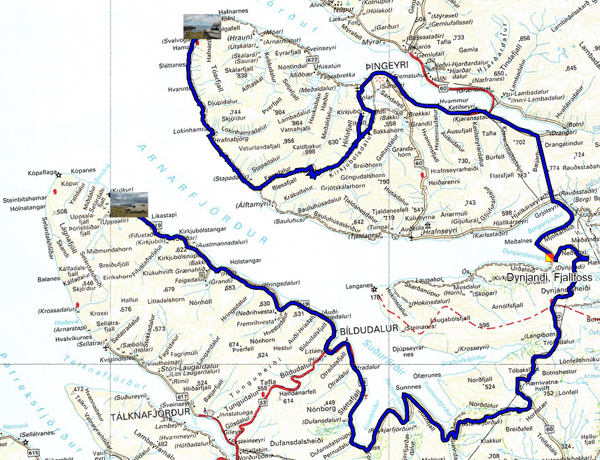
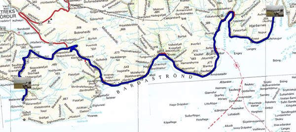
The GPS road tacklog,
Clic on the pic for openning it
from Svalvogar to Museum Jonsson
from 2021/07/12 to 2021/07/12
Museum Jonsson, route 619
Monday July 12 I visited the west coast of the Þingeyri peninsula.
The dirt road crosses grandiose landscapes along a cliff from which
cascading torrents flow, cutting the track with easily crossable
fords. A cross road took me back to Þingeyri to publish the pages of
my website, no connection at the ends of the peninsula in Svalvogar.
I continued on the road 60 stopping to admire Dynjandi, Fjallfoss.
Finally I headed towards the Jonsson Museum after Bildudalur on the
619. Alas, I burst the left rear tire. It took me about 2h30 to
change the wheel! The Jonsson Museum presents the naive works of
this island sculptor. I bivouacked there.
click on the pic for opening the gallery

|
| Dynjandi, Fjallfoss |
|
|
| Þingeyri peninsula, Svalvogar route 622 |
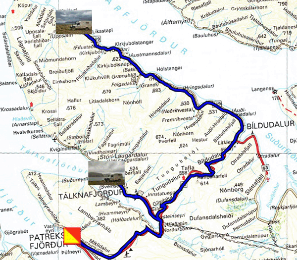
The GPS road tacklog,
Clic on the pic for openning it
from Museum Jonsson àto Talknafjördur
from 2021/07/13 to 2021/07/13
Talknafjördur, Pollurinn
Tuesday July 13 was a day like yesterday, rain and fog, my vehicle
bears the scars! I would go to Talknafjördur to check that Pollurinn
is indeed a hot spring and then I would go to Patreksfjördur to a
tire repairer. Finally I returned to Pollurinn to take a hot bath at
+ 35°C in the rain at 8°C, Icelanders love it. I bivouacked by
the water.
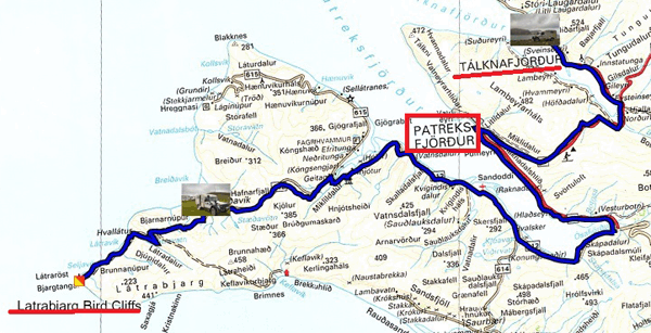
The GPS road tacklog,
Clic on the pic for openning it
from Talknafjördur à Latrabjarg Bird Cliffs
from 2021/07/14 to 2021/07/14
Latrabjarg Peninsula, Breidavik
Mercredi 14 juillet, Fête Nationale de France, fut ici en Islande encore
un jour de froid et de pluie pour visiter le Latrabjarg Bird Cliffs où
des milliers d’oiseaux sont venus nidifier de juin à mi-août. Le
parcourt le long de la falaise est escapé, gras, glissant et, dangereux
pour les chasseurs de photos inédites s’approchant de son bord friable,
ce ne fut pas mon cas. Le site de toilette à Brunnar annoncé comme
campsite gratuit par le Lonely Planet est prohibé. Je m’arrêtais à Breidavik
Hotel pour planter mon tipi.
click on the pic for opening the gallery
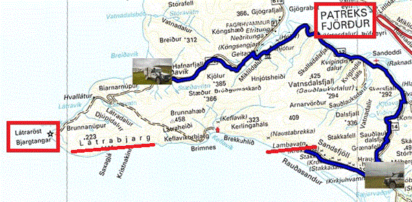
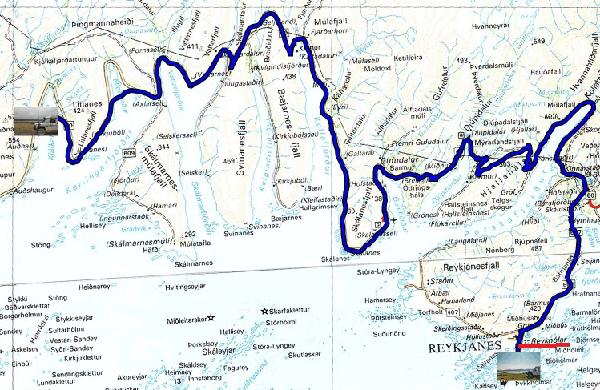
The GPS road tacklog,
Clic on the pic for openning it
from Latrabjarg Bird Cliffs to Melanes road
from 2021/07/15 to 2021/07/15
Latrabjarg Peninsula, Melanes road
Thursday July 15 was a two hour drive in the cold, 7°C, and the fog
almost flush with the hood, without interest. The landscape of the
coast of Raudasandur is announced as remarkable by the color of the
pink and red sand barely visible in the second photo below. The
recently ripolined Saurbaerkircha Church is of course closed. The
Evangelical Lutheran religion is elitist, dedicated to people of
strict observance! In France, Catholic churches are open from
morning until evening for shoppers of any religion or not. I put my
trailer on a dump near a dumpster, as there is often in Iceland,
ecology obliges. Two countries of the European Union are known for
the ecological behavior of their populations, in decreasing order,
Denmark, Iceland, and Switzerland.
 |
| SaurbaerKircha |
The GPS road tacklog,
Clic on the pic for openning it
from Melanes road to road 60
from 2021/07/16 to 2021/07/16
Road 60
Friday July 16 I'm still sailing in the clouds and in the rain. In
desperation I took pictures of the hydrographic system along Route
60 as an example of the extent of runoff and erosion that has been
wrought over millions of years in Iceland. The last photo is the
text of the statue in Icelandic which I do not understand!
click on the pic for opening the gallery
The GPS road tacklog,
Clic on the pic for openning it
from road 60 to Reykholar
from 2021/07/17 to 2021/07/17
Reykholar
Saturday July 17, finally the sun came bringing a little warmth and
comfort, both moral and physical. The landscapes are always
grandiose, but unfortunately the photos do not reflect their
splendor. This region is very sparsely populated, relative to
Iceland. One photo shows a house in the middle of nowhere. The
hamlet of Reykholar on the southern edge of the Reykjanes Peninsula
is a nesting place for eagles in the many small islands.
click on the pic for opening the gallery

|
| Reykholar |
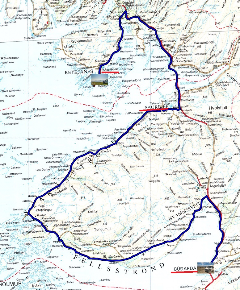
The GPS road tacklog,
Clic on the pic for openning it
from Reykholar to Budardalur
from 2021/07/18 to 2021/07/18
Budardalur
Sunday July 18th it was a dark day, but the weather is very
changeable in Iceland. I decided to travel the peninsula that I
called Saurbaer having not found its name. Route 590 follows the
bank between the fjord and the mountains. According to an
interpretive panel it is part of Icelandic history. It is very
sparsely populated depending on the width of the land used for
grazing sheep and the cultivation of fodder plants. Arriving in
Budardalur the weather cleared up and the temperature climbed to
14°C. I bivouacked in the port.
click on the pic for opening the gallery


