|
|
 |
Chile,
Atacama desert |
|
The journey to Chile
consists of the visit of the desert of Atacama and the climb of two
volcanos, Licancabur and Guallatiri.
An apparently absolute
aridity, large rock areas as far as the eye can see, gigantic volcanos,
blinding salars... Atacama is also an expansion of colours, hidden
oases, fragile pink flamingos, lakes with incredible colours, geysers
and human traces dating from the dawn of time..
This journey proposed to discover this magnificent area
with another view : splendid walks and two very different climbs showed
us the deep face of it by revealing us its most intimate secrecies under
the purest sky of the planet.
It was made in 2002, from the 07 to August 27. After
a 17-hour Air France flight via Buenos Aires, the arrival on Santiago
was on time and going through customs went finely. The way from the airport
to the hotel, downtown, made us discover the centre of Chile, green
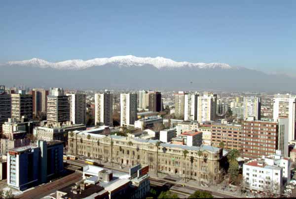
landscapes, food crops, fruits, vegetables, vines. The capital, Santiago,
lies at the foot of the Andean, approximately 500m high and 140 km from
the Pacific Ocean.
Lodging and food met the European standards, Santiago
is a piece of Spain. |
|
|
|
|
Santiago |
|
|
|
 |
|
Santiago |
 |
|
Safety! |
|
|
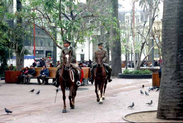
The
city of Santiago looks like all the colonial cities of the Spanish
Conquest. The Plaza de Armas is surrounded by Santiago Cathedral,
the San Agustin church and museums among which that Pre-Colombus arts.
The city has many parks located at the foot of the snow-covered
mountains of the Andean. It is very polluted and not pleasant for walks,
except the Santa Lucia hill and Parque Metropolitano.
Safety did not pose any problem, the dictatorship left indelible
traces in the behaviour of the inhabitants. The police force, though
discreet, was quite present. I used their courteous but firm assistance
to seek the holding bank of my bank which had moved. Consequently the
police officers speaking perfect English accompanied me to an exchange
agency awaiting and verifying the good end of the operation. |
|
|
|
|
|
The stay started with the
transfer by plane to Antofagasta, on coast of the Pacific Ocean,
and by a visit to Portada, arch on the sea cut by the waves,
the spray and the wind, similar to Delicate Arch of Arches National Park
of the American west.
The means of transport of the group of the twelve hikers was ensured by
cross-country vehicles, two light Toyota trucks and a large Ford F350.
No major incident occurred during the stay.
The road to Salar d' Atacama followed the way of miners,
from west to east, passing through a ghost town with a rotunda of unused
engines of the mining railroad company. |
|
|
|
|
Salar of Atacama |
|
|
|
 |
|
Salar d'Atacama |
 |
| Laguna de Aguas Calientes |
|
|
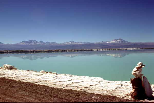
The salar of Atacama,
vast saltworks, took part in our acclimatization, the altitude is on
average 3,000 m high. It is the paradise of pink flamingos and archaeological ruins.
The climb towards the cordillera was the occasion to admire
Lagunas Miñiques and Miscanti with turquoise water
more than 4,000 m high and with the climb of a hill to 4,200 m in
a case of snow-covered volcanos.
The continuation towards the Argentinean border made us meet
geologists in search of ground water. They spend six months
in the desert drilling the ground to seek water for marketing.
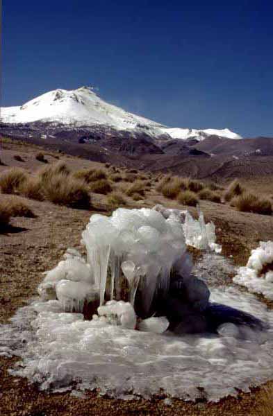
The salar and Laguna de Aguas Calientes enabled us to
rest our feet and legs in hot and sulphurous water.
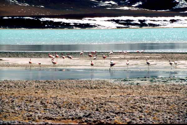
The landscapes are
enhanced by the colonies of pink flamingos, the wild goose flights
and the herds of vicunas and guanacos. It was a rapture of the eyes
with camaieux of colours, the dazzling of the saltworks and snows of
the surrounding mountains, not to mention the hot sources of
volcanic origin:
An unique experience. |
|
|
|
|
|
San Pedro of Atacama |
|
|
|
|
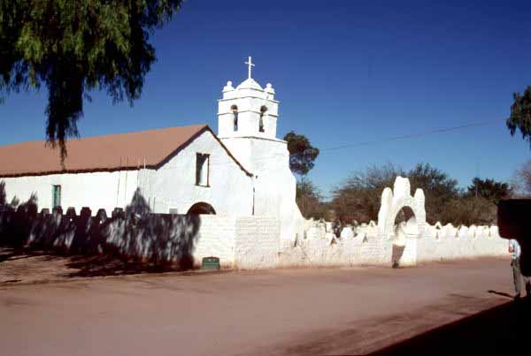
The road to San
Pedro of Atacama was of a very monotonous by its straightness and
alternation of rises and descents, with no people around.
The town is typically a
town of passage for trekkers, bikers, rafters, thus the presence of many
agencies, back bag groups, restaurants buzzing with foreign languages
and animated conversations about excursions and climbs.
The town was charming,
its archaeological and ethnological museum, Museo Padre Le Paige,
was remarkable for its didactic presentation of Pre-Colombus civilization.
The town hall square was a harbour of peace in the shade of large
trees. The church of the time of the conquest, 1461, was remarkable for its
roof, reversed careen with the apparent frame, its thick adobe wall, and
the naivety of its crib.
The sunset in the Valle de la Luna was an
unforgettable spectacle. This geological undulation in the Cordillera de la
Sal looks like the dune of Pilat (France), but in addition it offers an
unrestricted view on Licancabur, omnipresent at San Pedro. |
|
 |
|
San Pedro d'Atacama |
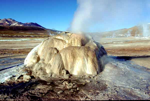 |
| Geiser del Tatio |
|
|
|
|
|
|
The days before the
climb were occupied finishing the acclimatization by walks in canyons at
an average 3,000 m high. We took part in the noisy and coloured
preparations of the Assumption Day at the village of Machuca.
This phase of transfer enabled us to profit from a halt at the thermal
baths of Puritama 3,400 m high. Then the arrival in
Geiser del Tatio to 4,300 m at the end of the day was a rapture
for the eyes. At this altitude the walk towards the geysers was made on
a cold ground of snow cracking under the feet. In the
early morning the sight of the geysers in the low-angled light was an
astonishment for us, we could not get away from it.
Return to San Pedro to cross the border to Bolivia towards
Laguna Verde in a cold and windy desert. |
|
|
|
|
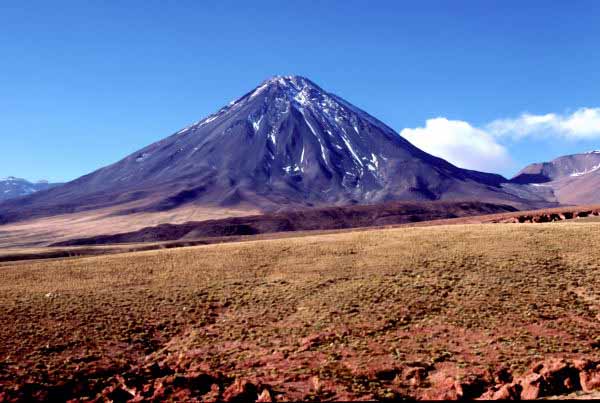
Licancabur, 5,916 m |
|
|
|
 |
|
Licancabur |
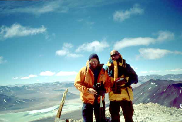 |
| At the summit |
|
|
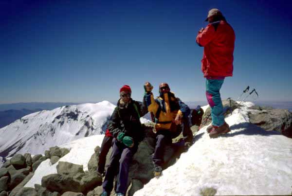
The
Licancabur volcano is located 30 km away from San Pedro of Atacama and
the base camp is 4,700 m high close to Incas ruins. This volcano is a
cone almost as perfect as that of Parinacota.
The climb by a ridge of
solidified lava did not require special equipment. On the other
hand the climb and especially the descent of the falls of lava were
tying for our legs. The instability of certain blocks
took part in tiredness and slowed down the descent. The summit of the crater
is occupied by a usually frozen lake and inca ruins. The sight on
the altiplano and Laguna Verde was impressive.
It took between 10 and 12 hours of walk
to go and back.
|
|
|
|
|
|
The return to San Pedro
allowed a refreshing halt at the hotel. The continuation of the
journey towards north to reach the base camp of Guallatiri while crossing salars
and natural parks in three days completed the acclimatization. |
|
|
|
|
Isluga, Lauca National parks |
|
|
|
|
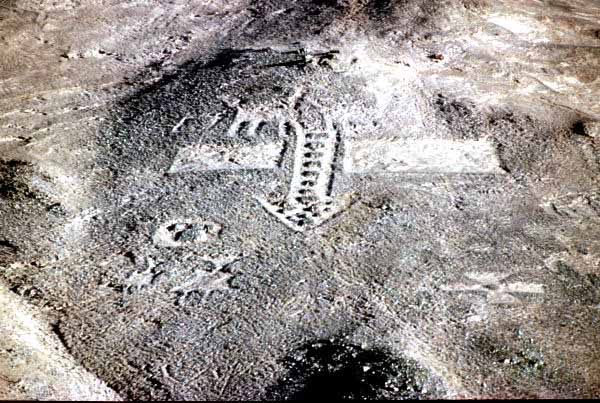
These days of transit
started with the Pan-American we could admire the géoglyphes of
Cerro Pintado which look like the site of Nasca in Peru.
The crossing of the Isluga park,
of the salar of Surire, of the Lauca park offered us
the observation of fauna so particular to this area of the world,
pink flamingos, wild geese, vicunas, guanacos etc.
This transit before the climb was the occasion
to visit Indian villages dating from the Spanish conquest with churches
with adobe walls, thatched roofs with adjacent bell-towers and dry
stone-built houses.
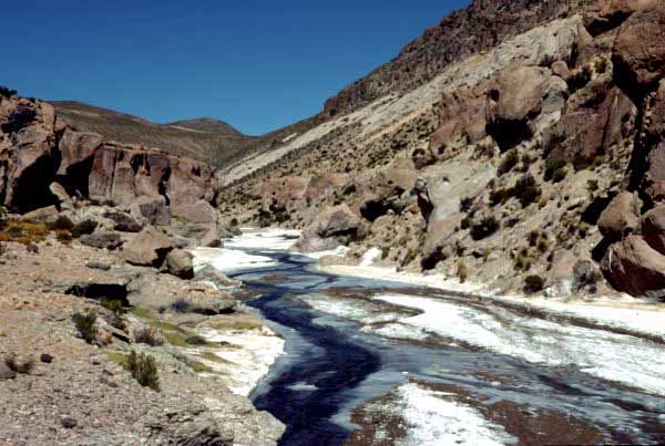
The acclimatization continued with walks in canyons
occupied by partially frozen rivers and with the edges bleached by salt.
In the sun the alternation of the white was strange, by confusing salt and ice. |
|
 |
|
Cerro Pintado |
 |
| Canyon |
|
|
|
|
|
|
The vehicles generally
followed dusty tracks located on average +3,500 m. Traffic in national
parks is bounded to a preliminary authorization. The safeguard of nature
is at this price.
The base camp was located at 4,200 m with a view on the volcano which
spat out yellowish smoke and gas. The evening was occupied with the preparations
and the dinner was a typical pasta party the days before of climb. |
|
|
|
|
Guallatiri, 6,063 m |
|
|
|
 |
|
Guallatiri |
 |
| At the top |
|
|
The
Guallatiri volcano is located in a lunar landscape. the departure of
the rise is 5,000 m high. This volcano looks like a crushed cake is
close to splendid Parinacota +6,342 m high.
The climb of this active volcano required to
fit the cramps to cross the névés and the glaciers covered with penitents.
The difficulty of the climb then of the descent was of nothing comparable
with that the falls of Licancabur. At the top the sight on Altiplano
and Parinacota was fairy-like, lunar scoria landscape with shades of
brown dark under the low-angled light of the early morning.
It took between 8 and 10 hours of walk to go and back.
|
|
|
|
|
|
The return was
by the descent of Altiplano towards the town of Arica on coast
of the Pacific Ocean and close to Peru where we took the plane to Santiago.
This way allowed us to see and admire the Chungara lake,
the villages of Parinacota and its church with its walls covered
with frescos, and Putre.
The road was of very good quality but the traffic was heavy with many trucks
transporting boron. On the way we could see cacti candelabra, and green valleys,
oasis with three annual harvests. The practice of burn-beating covered the
valleys with a light and odorous mist. |
|
|
|
|
The return to Santiago was
made in scheduled flight on domestic flight on time, early in the afternoon
on Sunday, without problem.
Then the return to France was made, after one night of
transit, in Air France flight via Buenos Aires with departure in the middle
of the night and on arrival in Paris in the middle of morning the next day.
The outward journey as well as the return added no difficulty
to this trekking |
|
|
|
| Neuilly, le 2003/06/14 |
|
|
|
|
|
|