-- From Townsville to Cooktown

The road tracklog
From
Townsville to Mt Molloy
from 2010/07/12 to 2010/07/18
Still a Monday of publication of website new pages en route in Ingham. The Library was equipped with three computers connected to Internet but not with Wireless. Consequently I used my script of DOS commands extremely opportunely prepared. My mailboxt did not show me a good news for the two future countries. I carried on my road to go closer to Cairns. The sky was of a very dark black, I would have been believed in Malaysia, indeed I was beyond the Tropic. The bivouac envisaged was in Babinda on a wet ground. It was a unspecified day.

Ciel plombé
en route
12/07/2010
I arrived in Cairns around 9 a.m. with a temperature of approximately 20°C. The city does not have many attractions if is not to be a famous seaside resort. Many summer hiring buildings border the esplanade occupied by restaurants and shops for tourists. I was going to make my harvest of booklets in Visitor Centre and to inquire about road conditions to Cape York, the end of the end of Australia in the north of the latitude of Darwin and close to Papua New Guinea. I decided to try my chance to reach Tip of Australia. After the full diesel and food I moved towards Mt Molloy where I bivouacked close to the cemetery, the rest area being crammed.
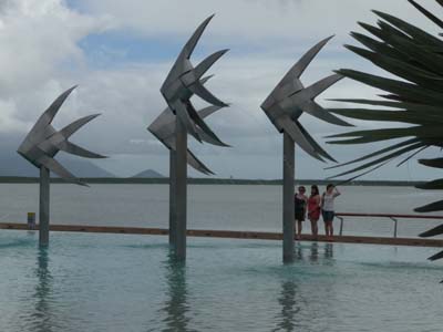
The Beach & the pool
Cairns
13/07/2010

Colonial building
Cairns
13/07/2010
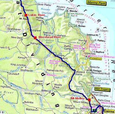
The road tracklog
Froml Mt Molloy to Lukin River
From 12/07/2010 to 18/07/2010
Cape York Peninsula
The Peninsula of the Cape York is the northern land end of Australia, the
Torres strait separates it from Papua New Guinea. Its surface is similar to that of the
United Kingdom; approximately 200000 km². I do not resist the pleasure of
quoting the dithyrambic prose by Lonely Planet.
" … The overland pilgrimage to Cape York Peninsula –the Tip of Australia– is
simply one of greatest 4WD routes on the continent. This one of the most untamed,
primeval and lonesome areas of Australia, where clouds of red dust signal
approaching vehicles and you’ll drive many kilometres on corrugated roads to
reach the next ”town”, usually an isolated roadhouse. While reaching the tip
in an exhilarating effort, many of the highlights of the journey are found in
the changing landscapes of the seasons and the detours, planned and
unexpected...”
As of early dawn I left the bivouac to reach, perhaps, Cape York. Up to Laura the road was asphalted then it was a gravel road with sometimes bitumen sections and often corrugated sheet. In Laura I deflated the tires to deaden shocks and to have more comfort, relative. I stopped at 4h30pm right before a small rain of large drops.

Sign post
Laura
14/07/2010

Gravel road
En route
14/07/2010
The following day was a long day on gravel road in monotonous landscapes. Only animation was the signposts announcing a bitumen section to rest the driver and to slacken his nervous tension. The AQIS is always omnipresent in Australia. Well, there are the courageous ones!

En route
15/07/2010

Bitumen
En route
15/07/2010

En route
15/07/2010

Courage!
En route
15/07/2010

The road tracklog
From Lukin River to "The Tip" and back
From 12/07/2010 to 18/07/2010
July 16 was a painful day to reach "The Tip", the northern point of the Australian continent. From Bamaga the track was corrugated with very deep waves then in underwood it became very narrow; fortunately I did not meet any vehicle as well in the outward journey as in the return. On the other hand the branches of trees were very low obliging me to stop my truck in a providential tailboard at less than one kilometre away from the Cape York where I went on foot. Providential in more than one way because the carpark was already occupied by ten 4x4 not offering any space for my truck both to station and to operate. A maritime drizzle was there to take pictures, sublime! At the back I took again the ferry, very expensive A$110, to return to Cairns. I bivouacked on the move.

Jardine Ferry
En route
16/07/2010

Sous-bois
En route
16/07/2010

The Tip
16/07/2010

The road tracklog
From Morehead to Cooktown
From 12/07/2010 to 18/07/2010
A long driving day on the return. The straight lines as far as the eye can see, already headed, were favourable with the meditation on my former and current life. My life was not a long quiet river, not even taken with arm the body. I incite the net surfers to read, read again and contemplate the book: “How to make yourself your misfortune” by Paul Watzlawick. I bivouacked on a sordid rest area, that exists in Australia.

Termite mounds
En route
17/07/2010

Corrugated track
En route
17/07/2010
On Sunday July 18 on the way I stopped at Split Rock shortly away after Laura to re-inflate the tires of my truck then to visit the art rock by local Aboriginals, very different from those already seen.

Split Rock
En route
18/07/2010

Split Rock
En route
18/07/2010
In Cooktown all caravan parks did not have any more place, I was successful to convince the caretaker of Orchid Travellers Park to lodge me for one night. Then I was going to explore the city's sights where Cpt James Cook beached from June 17 to August 4, 1770 to repair the damages caused by the coral reefs. The museum is sheltered in the old St May's convent, it exhibits in particular the anchor of Endeavour and other objects of Cook's expedition. Others rooms present the gold rush at Palmer River which attracted approximately 18000 Chinese accounting for 90% of the population at that time. Today the city counts no more 2000 inhabitants.

Couvent St Marie
Cooktown
18/07/2010
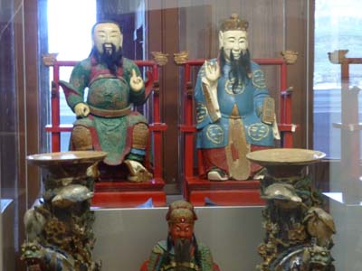
Chinese
Statues
Cooktowne
18/07/2010

The Old Bank
Cooktown
18/07/2010
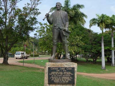
Cpt James Cook
Cooktown
18/07/2010
My expedition to Cape York lasted 5 days and traversed 1500km of gravel roads. Was it necessary to undertake it? Men from immemorial time were attracted by sea and failed in front of “land ends”. Hordes from the steppes of the Central Asia stopped at the end of the Indo-European plain, the French coasts of the Atlantic. Boldest, the Celts, crossed the English Channel to settle in Wales and in Ireland. I did not escape this myth. No, I will not remain in the Cape York Peninsula, but it was an interesting experience in all connections.